功能說明
Your next tide, at a glance.
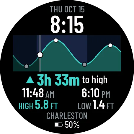
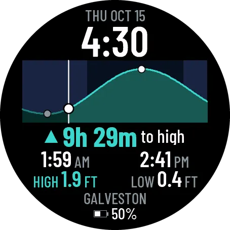
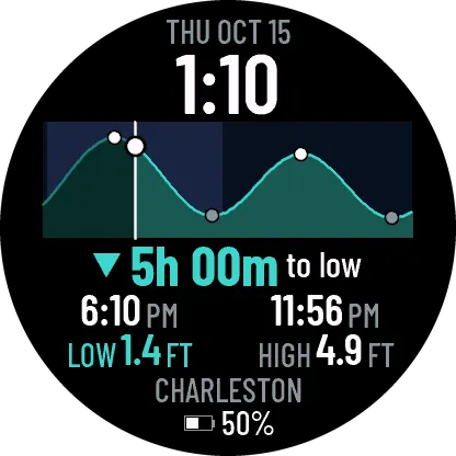
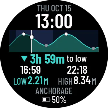
Tide Line is a watch face for anglers, surfers, paddlers and boaters. It shows the tide curve for the next 18 hours, whether the water is rising or falling, how long until the next high or low, and the times and heights of the next two tides, from the nearest NOAA tide station.
THE TIDE
• A 24-hour tide curve with a marker for now: 6 hours back, 18 hours ahead, with day and night shading.
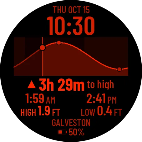
• Rising or falling arrow and a countdown: "2h 14m to high".
• The next two tides in big type: time (with AM/PM) and height, e.g. HIGH 1:59 AM 1.9 FT, LOW 2:41 PM 0.4 FT.
• Heights in feet or meters, above MLLW (the chart datum used by NOAA tide tables).
• Station name, so you know which station you're reading.
NEAREST STATION, AUTOMATICALLY
Tide Line carries NOAA's list of about 3,500 US tide prediction stations (US coasts, Alaska, Hawaii, Puerto Rico, the Pacific islands). It picks the nearest one to your watch's last known position, or you can type a NOAA station ID in the settings.
WORKS OFFLINE
About twice a day, when your phone is connected, the face downloads 5 days of NOAA high/low predictions in the background. With no phone, the cached tides keep working for 3 to 4 days, and if the data gets old the face says so ("DATA 2D OLD"). It never guesses.
EVERYTHING ELSE
• Time, date and battery.
• 12- or 24-hour time, five accent colors.
• Red night mode for the boat at night: always on, or automatic after sunset. Touch and hold to flip it.
• Large, high-contrast text, sized for a glance on a moving deck.
• Battery-friendly always-on display: dim clock and "high in 2h 14m", shifted every minute.
CLEAR STATES
NEED LOCATION (start a GPS activity once), NO TIDE STATION (none within 100 km), NO TIDE DATA (connect your phone and open Garmin Connect), STATION NOT FOUND (check the ID).
COVERAGE
NOAA stations cover the United States and its territories. Outside them the face shows NO TIDE STATION. Requires a phone with Garmin Connect for downloads.
IMPORTANT
Not for navigation. Predictions are estimates; actual water levels vary with weather, wind, pressure, river flow and storm surge, and can differ a lot from the prediction. The curve between high and low is an approximation. Check official sources and local conditions before you go, and keep a safety margin. You are responsible for your safety and your vessel; never rely on this watch face alone.
Tide predictions: NOAA CO-OPS. Not affiliated with or endorsed by NOAA.
Supports AMOLED Forerunner, fenix, epix, Venu, vivoactive, Instinct AMOLED, MARQ, Descent, D2 and Approach watches.
Questions or a station that doesn't work: [email protected]
更新記錄
Settings changed on the watch or in the phone app now apply right away, without restarting the face. Fixed phone settings, including a numeric Station ID, being ignored. Improved always-on mode so the face no longer loads station data while dimmed.
螢幕截圖
支援語言(1)
相容機型(64)
Approach® S50
Approach® S70 (42mm)
Approach® S70 (47mm)
Approach® S72 - 43 mm
Approach® S72 - 47 mm
D2™ Air X10
D2™ Air X15
D2™ Mach 1
D2™ Mach 1 Pro
D2™ Mach 2
D2™ Mach 2 Pro
Descent™ G2
Descent™ MK3 - 43mm
Descent™ MK3i - 51mm
epix™ (Gen 2)
epix™ (Gen 2)
epix™ Pro (42mm)
epix™ Pro (47mm)
epix™ Pro (51mm)
fēnix® 8 AMOLED (43mm)
fēnix® 8 AMOLED (47mm/51mm)
fēnix® 8 Pro
fenix® 9 - 43 mm
fenix® 9 – 47 mm
fenix® 9 Pro - 43 mm
fenix® 9 Pro - 47 mm
fenix® 9 Pro - 51 mm
fēnix® E
Forerunner® 165
Forerunner® 165 Music
Forerunner® 170
Forerunner® 170 Music
Forerunner® 265
Forerunner® 265S
Forerunner® 570 - 42mm
Forerunner® 570 - 47mm
Forerunner® 70
Forerunner® 70
Forerunner® 965
Forerunner® 970
Instinct® 3 – 45 mm, AMOLED
Instinct® 3 – 50 mm, AMOLED
Instinct® Crossover AMOLED
MARQ® (Gen 2)
MARQ® Commander (Gen 2) – Carbon Edition
MARQ™ Aviator (Gen 2)
Mercedes-Benz Venu® 2
Mercedes-Benz Venu® 2
Mercedes-Benz Venu® 2S
Mercedes-Benz Venu® 2S
tactix® 7 – AMOLED Edition
tactix® 8 – 47 mm, AMOLED
Venu® 2
Venu® 2
Venu® 2 Plus
Venu® 2 Plus
Venu® 2S
Venu® 2S
Venu® 3
Venu® 3S
Venu® 4 – 41 mm
Venu® 4 – 45 mm
vívoactive® 5
vívoactive® 6